Toggle navigation
Browse
Browse
Archival descriptions
People and Organizations
Subjects
Places
Digital objects
Search
Search options
Advanced search
Search in browse page
Clipboard
Clipboard
Clipboard
Clear all selections
Go to clipboard
Load clipboard
Save clipboard
Language
Language
Language
English
Français
Español
Nederlands
Português
Quick links
Quick links
Quick links
Home
About
Help
Privacy Policy
Log in
Have an account?
Email
*
This field is required.
Password
*
This field is required.
Log in
Narrow your results by:
Part of
All
Saanich Planning Department Photograph fonds
, 38 results
38
Girling fonds
, 31 results
31
Saanich Engineering Department photograph collection
, 19 results
19
Saanich Public Works Photograph fonds
, 14 results
14
Saanich Mayor’s Office Photograph fonds
, 6 results
6
Saanich Police photograph fonds
, 6 results
6
Saanich Archives Collection
, 6 results
6
Duncan McTavish fonds
, 5 results
5
Saanich Clerk’s Office photograph fonds
, 4 results
4
Gray family fonds
, 4 results
4
Name
All
Sehl family
, 1 results
1
Dominion Astrophysical Observatory
, 1 results
1
Bradshaw family
, 1 results
1
Estlin, Charles Prior
, 1 results
1
Place
All
Tillicum
, 40 results
40
Quadra
, 24 results
24
Gordon Head
, 15 results
15
BC
, 13 results
13
Shelbourne
, 11 results
11
Carey
, 11 results
11
Victoria (B.C.)
, 11 results
11
Saanich Core
, 9 results
9
Cadboro Bay
, 7 results
7
Cordova Bay
, 5 results
5
Subject
All
Roads
, 183 results
183
Buildings-Private
, 29 results
29
Buildings-Commercial
, 27 results
27
Vehicles
, 25 results
25
Automobiles
, 25 results
25
Houses
, 14 results
14
Farms
, 9 results
9
Animals
, 9 results
9
Snow
, 9 results
9
Trees
, 6 results
6
Genre
All
Photographs
, 36 results
36
Aerial photographs
, 16 results
16
Print preview
Close
Showing 183 results
Archival description
Remove filter:
Roads
Remove filter:
With digital objects
Advanced search options
Find results with:
and
or
not
in
Any field
Title
Archival history
Scope and content
Extent and medium
Subject access points
Name access points
Place access points
Genre access points
Identifier
Reference code
Digital object text
Creator
Finding aid text
Any field except finding aid text
Delete criterion
Add new criteria
And
Or
Not
Limit results to:
Top-level description
Filter results by:
Level of description
Collection
File
Fonds
Item
Part
Series
Subfonds
Subseries
Digital object available
Yes
No
Finding aid
Yes
No
Generated
Uploaded
Copyright status
Public domain
Under copyright
Unknown
General material designation
Architectural drawing
Cartographic material
Graphic material
Moving images
Multiple media
Object
Philatelic record
Sound recording
Technical drawing
Textual record
Top-level description filter
Top-level descriptions
All descriptions
Filter by date range:
Start
End
Results
Overlapping
Exact
Print preview
Card view
Table view
Sort by: Start date
Date modified
Title
Relevance
Identifier
Reference code
Start date
End date
Direction: Ascending
Ascending
Descending
Cedar Hill Cross Road near school, 1880
Add to clipboard
Looking south on Richmond Road near Lansdowne
Add to clipboard
Horse-drawn carriage on road
Add to clipboard
Palmer Station in View Royal, 1900
Add to clipboard
View of Elliot Street with Helmcken house, early 1900s
Add to clipboard
Prairie road
Add to clipboard
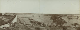
View from Mount Tolmie showing Richmond Road and Cedar Hill Cross Road, 1900
Add to clipboard
[Beale family farm, Cadboro Bay Road]
Add to clipboard
Inner Harbour, Victoria showing James Bay and Church Hill, early 1900s
Add to clipboard
Prairie landscape
Add to clipboard
Results 1 to 10 of 183
Previous
1
2
3
4
5
6
7
...
19
Next